| River order
|
Name
|
Image
|
Location
Coordinates
|
Carries
|
Date
|
Heritage
status
|
Notes
|
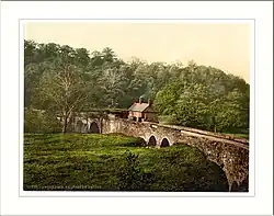
| 1 |
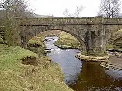
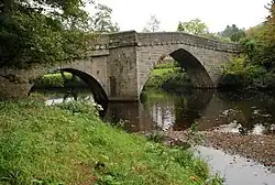
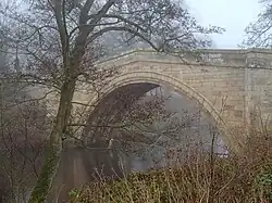
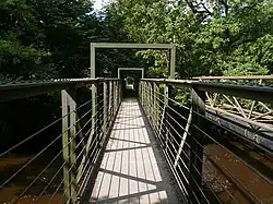
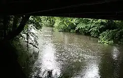
Slippery Stones packhorse bridge |
 |
Hope Woodlands
53°27′09″N 1°44′48″W / 53.45260°N 1.74661°W / 53.45260; -1.74661 (Slippery Stones) |
Footpath |
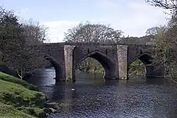
1672
(1959)
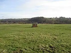
|
II
|
A 17th-century packhorse bridge that was relocated from Derwent village[8]
|
| 2 |
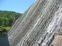
Howden Dam |
 |
Howden Reservoir
53°26′00″N 1°45′00″W / 53.43333°N 1.75000°W / 53.43333; -1.75000 (Howden Dam) |
– |
1912
|
II
|
For information
|
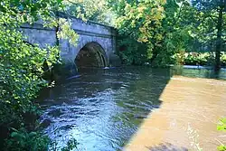
| 3 |
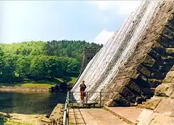
Derwent Dam |
 |
Derwent Reservoir
53°24′18″N 1°44′30″W / 53.40503°N 1.74167°W / 53.40503; -1.74167 (Derwent Dam) |
– |
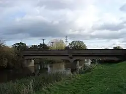
1916
|
II
|
For information
|
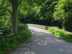
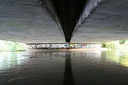
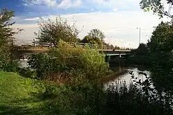
| 4 |
Fairholmes Bridge |
.jpg) |
Derwent Reservoir
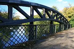
53°24′09″N 1°44′32″W / 53.40260°N 1.74219°W / 53.40260; -1.74219 (Fairholmes Bridge) |
Derwent Lane |
|
-
|
Stone arch bridge
|
| 5 |
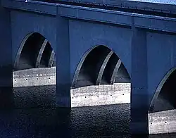
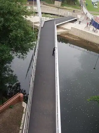
Ashopton Viaduct |
 |
Ladybower Reservoir
53°22′29″N 1°42′41″W / 53.37465°N 1.71147°W / 53.37465; -1.71147 (Ashopton Viaduct) |
A57 |
1943
|
-
|
Concrete viaduct
|
| 6 |
Ladybower Dam |
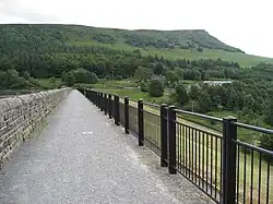 |
Ladybower Reservoir
53°21′57″N 1°42′04″W / 53.3657°N 1.7011°W / 53.3657; -1.7011 (Ladybower Dam) |
Footpath |
1943
|
-
|
Footway along dam wall
|
| 7 |
Yorkshire Bridge |
 |
Yorkshire Bridge
53°21′40″N 1°42′14″W / 53.36123°N 1.70386°W / 53.36123; -1.70386 (Yorkshire Bridge) |
Lydgate Lane |
1800s
|
II
|
Stone arch bridge[12]
|
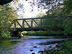
| 8 |
Bamford Mill footbridge |
.jpg) |
Bamford
53°20′48″N 1°41′39″W / 53.34659°N 1.69411°W / 53.34659; -1.69411 (Bamford Mill footbridge) |
Footpath |
|
-
|
Wooden footbridge at Bamford Mill
|
| 9 |
Water Lane bridge |
.jpg) |
Bamford
53°20′34″N 1°41′34″W / 53.34284°N 1.69273°W / 53.34284; -1.69273 (Water Lane bridge) |
Water Lane |
|
-
|
Minor road bridge
|
| 10 |
Railway bridge |
.jpg) |
Bamford
53°20′25″N 1°41′32″W / 53.34014°N 1.69230°W / 53.34014; -1.69230 (Railway bridge) |
Hope Valley line |
|
-
|
Rail bridge
|
| 11 |
Mytham Bridge |
.jpg) |
Bamford
53°20′21″N 1°41′38″W / 53.33917°N 1.69388°W / 53.33917; -1.69388 (Mytham Bridge) |
A6187 |
|
-
|
Stone arch bridge with adjacent footbridge
|
| 12 |
Hathersage stepping stones |
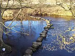 |
Hathersage
53°19′50″N 1°40′31″W / 53.33048°N 1.67540°W / 53.33048; -1.67540 (Hathersage stepping stones) |
Footpath |
|
-
|
Between Offerton and Hathersage
|
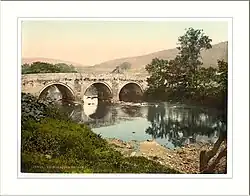
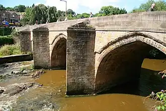
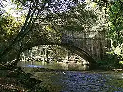
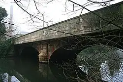
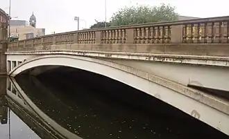
| 13 |
Leadmill Bridge |
 |
Hathersage
53°19′19″N 1°39′04″W / 53.32187°N 1.65102°W / 53.32187; -1.65102 (Leadmill Bridge) |
B6001 |
18th century
|
II
|
Stone arch bridge – widened in 1928[15]
|
| 14 |
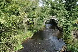
Grindleford Bridge |
 |
Grindleford
53°17′48″N 1°38′03″W / 53.29675°N 1.63415°W / 53.29675; -1.63415 (Grindleford Bridge) |
B6251 |
|
II & SM
|
Stone arch bridge[17]
|
| 15 |
Froggatt Bridge |
 |
Froggatt
53°16′52″N 1°38′09″W / 53.28116°N 1.63585°W / 53.28116; -1.63585 (Froggatt Bridge) |
Minor Road |
19th century
|
SM
|
Stone arch bridge[18]
|
| 16 |
Froggatt New Bridge |
 |
Froggatt
53°16′28″N 1°38′08″W / 53.27445°N 1.63565°W / 53.27445; -1.63565 (Froggatt New Bridge) |
A625 |
|
-
|
Stone arch bridge
|
| 17 |
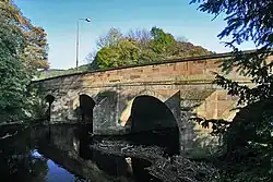
Calver Bridge |
 |
Calver
53°16′00″N 1°37′53″W / 53.26657°N 1.63146°W / 53.26657; -1.63146 (Calver Bridge) |
Minor road |
19th century
|
II*
|
Triple arched stone bridge[19]
|
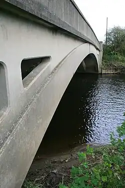
| 18 |
Calver Bridge (A623) |
.jpg) |
Calver
53°15′59″N 1°37′55″W / 53.26625°N 1.63206°W / 53.26625; -1.63206 (Calver Bridge (A623)) |
A623 |
1974
|
-
|
Modern bridge
|
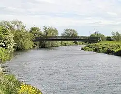
| 19 |
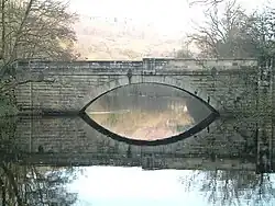
Baslow Bridge |
.jpg) |
Baslow
53°14′52″N 1°37′31″W / 53.24775°N 1.62527°W / 53.24775; -1.62527 (Baslow Bridge) |
Minor road |
1608
|
I & SM
|
Stone arch bridge with toll booth[21]
|
| 20 |
Devonshire Bridge |
.jpg) |
Baslow
53°14′46″N 1°37′24″W / 53.24604°N 1.62337°W / 53.24604; -1.62337 (Devonshire Bridge) |
A619 |
1925
|
-
|
Bakewell Road bridge
|
| 21 |
Chatsworth Park Bridge |
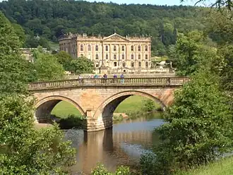 |
Chatsworth
53°13′41″N 1°36′58″W / 53.22800°N 1.61622°W / 53.22800; -1.61622 (Chatsworth Park Bridge) |
Minor road |
1774
|
I
|
Designed by James Paine, providing access to Chatsworth House[22]
|
| 22 |
One Arch Bridge |
 |
Chatsworth
53°12′45″N 1°36′40″W / 53.21241°N 1.61106°W / 53.21241; -1.61106 (One Arch Bridge) |
B6012 |
1760
|
II* & SM
|
Also designed by James Paine, linking Edensor to Beeley[24]
|
| 23 |
Rowsley Viaduct |
.jpg) |
Rowsley
53°11′25″N 1°37′06″W / 53.19038°N 1.61842°W / 53.19038; -1.61842 (Rowsley Viaduct) |
Unused |
1862
|
-
|
Former railway viaduct
|
| 24 |
Rowsley Bridge |
 |
Rowsley
53°11′22″N 1°37′02″W / 53.18957°N 1.61720°W / 53.18957; -1.61720 (Rowsley Bridge) |
A6 |
15th century
|
II* & SM
|
Stone arch bridge widened 1926[27]
|
| 25 |
Darley Bridge |
 |
Darley Bridge
53°09′18″N 1°35′49″W / 53.15508°N 1.59697°W / 53.15508; -1.59697 (Darley Bridge) |
B5057 |
15th century
|
II* & SM
|
Stone arch bridge[29]
|
| 26 |
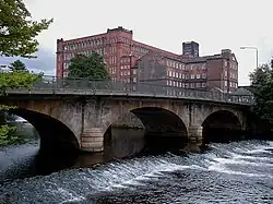
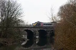
Peak Rail bridge |
 |
Matlock
53°08′31″N 1°34′08″W / 53.14200°N 1.56899°W / 53.14200; -1.56899 (Peak Rail bridge) |
Peak Rail |
|
-
|
Bridge 35
|
| 27 |
Derwent Way bridge |
.jpg) |
Matlock
53°08′27″N 1°33′53″W / 53.14074°N 1.56464°W / 53.14074; -1.56464 (Derwent Way bridge) |
A6 |
2007
|
-
|
Modern A6 bridge[31]
|
| 28 |
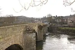
Matlock Bridge |
 |
Matlock
53°08′16″N 1°33′22″W / 53.13788°N 1.55622°W / 53.13788; -1.55622 (Matlock Bridge) |
Former A6 route restored and widened 1904 |
15th century
|
II* & SM
|
Stone arch bridge[33]
|
| 29 |
Hall Leys Park footbridge |
.jpg) |
Matlock
53°08′12″N 1°33′15″W / 53.13659°N 1.55414°W / 53.13659; -1.55414 (Hall Leys Park footbridge) |
Footpath |
|
-
|
The gateway to the bridge shows flood heights in 1960 and 1965
|
| 30 |
Railway bridge |
.jpg) |
Matlock
53°08′05″N 1°33′23″W / 53.13486°N 1.55643°W / 53.13486; -1.55643 (Railway bridge) |
Derwent Valley Line |
|
-
|
Rail bridge
|
| 31 |
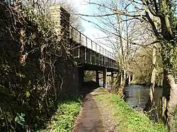
Footbridge |
.jpg) |
Matlock
53°08′00″N 1°33′25″W / 53.13333°N 1.55684°W / 53.13333; -1.55684 (Footbridge) |
Footpath |
|
-
|
Dale Road to Pic Tor
|
| 32 |
Footbridge |
.jpg) |
Matlock Bath
53°07′34″N 1°33′35″W / 53.12600°N 1.55975°W / 53.12600; -1.55975 (Footbridge) |
Footpath |
|
-
|
Dale Road to High Tor
|
| 33 |
Footbridge |
.jpg) |
Matlock Bath
53°07′26″N 1°33′28″W / 53.12386°N 1.55791°W / 53.12386; -1.55791 (Footbridge) |
Footpath |
|
-
|
Dale Road to cable car
|
| 34 |
Matlock Bath Bridge |
.jpg) |
Matlock Bath
53°07′19″N 1°33′28″W / 53.12189°N 1.55786°W / 53.12189; -1.55786 (Matlock Bath Bridge) |
Access road |
|
-
|
Access road to Station Yard
|
| 35 |
Jubilee Bridge, Matlock Bath |
 |
Matlock Bath
53°07′17″N 1°33′42″W / 53.12142°N 1.56154°W / 53.12142; -1.56154 (Jubilee Bridge, Matlock Bath) |
Footpath |
1887
|
-
|
Footbridge
|
| 36 |
Derwent Gardens footbridge |
.jpg) |
Matlock Bath
53°07′03″N 1°33′36″W / 53.11752°N 1.55990°W / 53.11752; -1.55990 (Derwent Gardens footbridge) |
Footpath |
1969
|
-
|
Modern footbridge linking Derwent Gardens to Lovers Walk; site of earlier Matlock ferry
|
| 37 |
Cromford Bridge |
 |
Cromford
53°06′40″N 1°33′11″W / 53.11101°N 1.55310°W / 53.11101; -1.55310 (Cromford Bridge) |
Mill Road |
15th century
|
II* & SM
|
Stone arch bridge[35]
|
| 38 |
Cromford railway bridge |
.jpg) |
Cromford
53°06′43″N 1°32′53″W / 53.11206°N 1.54809°W / 53.11206; -1.54809 (Cromford railway bridge) |
Derwent Valley Line |
|
-
|
Rail bridge
|
| 39 |
Access bridge (High peak junction) |
 |
High Peak Junction
53°06′03″N 1°31′54″W / 53.10074°N 1.53171°W / 53.10074; -1.53171 (Access bridge (High peak junction)) |
Access road |
|
-
|
Access to sewage works
|
| 40 |
Footbridge |
 |
High Peak Junction
53°06′02″N 1°31′53″W / 53.10060°N 1.53127°W / 53.10060; -1.53127 (Footbridge) |
Footpath |
|
-
|
High Peak Junction
|
| 41 |
Leawood railway bridge |
 |
High Peak Junction
53°05′52″N 1°31′44″W / 53.09778°N 1.52882°W / 53.09778; -1.52882 (Leawood railway bridge) |
Derwent Valley Line |
|
-
|
Rail bridge
|
| 42 |
Wigwell Aqueduct |
 |
High Peak Junction
53°05′49″N 1°31′47″W / 53.09693°N 1.52983°W / 53.09693; -1.52983 (Wigwell Aqueduct) |
Cromford Canal |
1790s
|
SM
|
Partially collapsed during construction; rebuilt at William Jessop's own expense[36]
|
| 43 |
Railway bridge |
.jpg) |
High Peak Junction
53°05′45″N 1°31′19″W / 53.09595°N 1.52191°W / 53.09595; -1.52191 (Railway bridge) |
Derwent Valley Line |
|
-
|
Rail bridge
|
| 44 |
Homesford footbridge |
.jpg) |
Whatstandwell
53°05′40″N 1°30′51″W / 53.09447°N 1.51415°W / 53.09447; -1.51415 (Homesford footbridge) |
Footpath |
|
-
|
Combined foot and pipe bridge
|
| 45 |
Railway bridge |
 |
Whatstandwell
53°05′23″N 1°30′25″W / 53.08979°N 1.50692°W / 53.08979; -1.50692 (Railway bridge – Whatstandwell) |
Derwent Valley Line |
|
-
|
Rail bridge
|
| 46 |
Whatstandwell Bridge |
 |
Whatstandwell
53°05′08″N 1°30′25″W / 53.08549°N 1.50704°W / 53.08549; -1.50704 (Whatstandwell Bridge) |
A6 |
1796
|
II
|
Stone arch bridge[38]
|
| 47 |
Oak Hurst mills bridge |
|
Ambergate
53°04′00″N 1°29′31″W / 53.06674°N 1.49193°W / 53.06674; -1.49193 (Oak Hurst mills bridge) |
Access road |
|
-
|
Access bridge
|
| 48 |
Halfpenny Bridge |
 |
Ambergate
53°03′34″N 1°29′02″W / 53.05942°N 1.48389°W / 53.05942; -1.48389 (Halfpenny Bridge) |
Holly Lane |
1792
|
II
|
Also known as Toad-Moor bridge, built as a toll bridge by Francis Hurt[40]
|
| 49 |
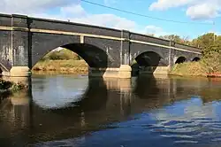
Derwent Viaduct |
 |
Ambergate
53°03′24″N 1°28′58″W / 53.05672°N 1.48288°W / 53.05672; -1.48288 (Derwent Viaduct) |
Midland Main Line |
1840
|
II*
|
Skewed rail bridge[41]
|
| 50 |
Railway bridge |
 |
Belper
53°02′45″N 1°29′06″W / 53.0458°N 1.4849°W / 53.0458; -1.4849 (Railway bridge) |
Midland Main Line |
|
-
|
Rail bridge
|
| 51 |
Railway bridge |
.jpg) |
Belper
53°01′56″N 1°28′59″W / 53.0321°N 1.4830°W / 53.0321; -1.4830 (Railway bridge) |
Midland Main Line |
|
-
|
Rail bridge
|
| 52 |
Belper Bridge |
 |
Belper
53°01′46″N 1°29′14″W / 53.02936°N 1.48725°W / 53.02936; -1.48725 (Belper Bridge) |
Bridge Foot |
1798
|
II
|
Tripled arched bridge[43]
|
| 53 |
Belper Meadows footbridge |
 |
Belper
53°01′30″N 1°29′30″W / 53.02505°N 1.49173°W / 53.02505; -1.49173 (Belper Meadows footbridge) |
Footpath |
|
-
|
Access bridge
|
| 54 |
Belper sewage works bridge |
 |
Belper
53°00′58″N 1°29′06″W / 53.01619°N 1.48501°W / 53.01619; -1.48501 (Belper sewage works bridge) |
Access road |
|
-
|
Access bridge
|
| 55 |
Swainsley Railway bridge |
.jpg) |
Belper
53°00′40″N 1°29′04″W / 53.01125°N 1.48433°W / 53.01125; -1.48433 (Swainsley Railway bridge) |
Midland Main Line |
|
-
|
Steel rail bridge
|
| 56 |
Milford Bridge |
 |
Milford
53°00′08″N 1°28′42″W / 53.00231°N 1.47840°W / 53.00231; -1.47840 (Milford Bridge) |
A6 |
1790
|
II
|
Stone arch bridge
|
| 57 |
Milford footbridge |
_(geograph_2421660).jpg) |
Milford
53°00′03″N 1°28′46″W / 53.00096°N 1.47936°W / 53.00096; -1.47936 (Milford footbridge) |
Footpath |
|
-
|
Garden centre access[45]
|
| 58 |
Moscow Farm bridge |
|
Milford
52°59′45″N 1°28′53″W / 52.99587°N 1.48139°W / 52.99587; -1.48139 (Moscow Farm bridge) |
Access road |
|
-
|
Access bridge
|
| 59 |
Duffield Church Bridge |
.jpg) |
Duffield
52°58′58″N 1°28′47″W / 52.98290°N 1.47961°W / 52.98290; -1.47961 (Duffield Church Bridge) |
Makeney Road |
Probable 16th century
|
II & SM
|
Stone arch bridge[46]
|
| 60 |
Burley Railway Bridge |
.jpg) |
Little Eaton
52°58′11″N 1°28′17″W / 52.96981°N 1.47143°W / 52.96981; -1.47143 (Burley Railway Bridge) |
Midland Main Line |
|
-
|
Rail bridge
|
| 61 |
Allestree Ford Bridge |
 |
Allestree
52°57′27″N 1°27′58″W / 52.95760°N 1.46619°W / 52.95760; -1.46619 (Allestree Ford Bridge) |
Ford Lane |
|
-
|
Former ford at this point
|
| 62 |
Allestree A38 Bridge |
 |
Allestree
52°57′20″N 1°28′03″W / 52.95568°N 1.46759°W / 52.95568; -1.46759 (Allestree A38 Bridge) |
Abbey Hill |
|
-
|
Dual carriageway bridge
|
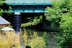
| 63 |
Darley Abbey toll bridge |
.jpg) |
Darley Abbey
52°56′36″N 1°28′33″W / 52.94332°N 1.47584°W / 52.94332; -1.47584 (Darley Abbey toll bridge) |
Haslams Lane |
|
-
|
The existing toll bridge was deemed unsafe for both foot and road traffic in 2022, and was subsequently replaced by a temporary pedestrian footbridge known as Walter's Walkway later that same year.[48]
|
| 64 |
Handyside Bridge |
 |
Derby
52°55′51″N 1°28′39″W / 52.93092°N 1.47747°W / 52.93092; -1.47747 (Handyside Bridge) |
Footpath |
1878
|
II
|
Former GNR railway bridge[50]
|
| 65 |
St Marys Bridge |
.jpg) |
Derby
52°55′38″N 1°28′31″W / 52.92716°N 1.47519°W / 52.92716; -1.47519 (St Marys Bridge) |
Minor road |
1793
|
II* & SM
|
Designed by Thomas Harrison, it replaced an earlier medieval bridge; adjacent is St Mary's Bridge Chapel.[51]
|
| 66 |
Causey Bridge |
 |
Derby
52°55′36″N 1°28′31″W / 52.92667°N 1.47521°W / 52.92667; -1.47521 (Causey Bridge) |
Saint Alkmunds Way |
1972
|
-
|
Dual carriageway bridge
|
| 67 |
Cathedral Green Footbridge |
 |
Derby
52°55′31″N 1°28′31″W / 52.92525°N 1.47522°W / 52.92525; -1.47522 (Cathedral Green footbridge) |
Footpath |
2009
|
-
|
Swing bridge[52]
|
| 68 |
Exeter Bridge |
 |
Derby
52°55′26″N 1°28′26″W / 52.92397°N 1.47382°W / 52.92397; -1.47382 (Exeter Bridge) |
Derwent Street |
1929
|
-
|
1920s road bridge, replaced earlier wooden bridge
|
| 69 |
Holmes Bridge |
.jpg) |
Derby
52°55′24″N 1°28′11″W / 52.92343°N 1.46968°W / 52.92343; -1.46968 (Holmes Bridge) |
A601 |
1972
|
-
|
Dual carriageway bridge
|
| 70 |
Bass Recreation Ground footbridge |
 |
Derby
52°55′17″N 1°27′57″W / 52.92139°N 1.46592°W / 52.92139; -1.46592 (Bass Recreation Ground footbridge) |
Footpath |
|
-
|
Modern footbridge
|
| 71 |
Derwent Bridge |
 |
Derby
52°55′10″N 1°27′50″W / 52.91952°N 1.46376°W / 52.91952; -1.46376 (Derwent Bridge) |
Midland Main Line |
1840
|
II
|
Skewed rail bridge, also known as Five Arches[53]
|
| 72 |
Derwent Parade bridge |
 |
Pride Park
52°55′03″N 1°26′35″W / 52.91761°N 1.44309°W / 52.91761; -1.44309 (Derwent Parade bridge) |
Derwent Parade |
|
-
|
Modern road bridge
|
| 73 |
Railway bridge Pride Park |
 |
Pride Park
52°54′40″N 1°26′26″W / 52.91104°N 1.44067°W / 52.91104; -1.44067 (Railway bridge Pride Park) |
Midland Main Line |
|
-
|
Midland Main Line
|
| 74 |
Raynesway Bridge |
 |
Derby
52°54′17″N 1°25′50″W / 52.90467°N 1.43049°W / 52.90467; -1.43049 (Raynesway Bridge) |
A5111 |
1938
|
-
|
A5111
|
| 75 |
Waste Incinerator bridge |
.jpg) |
Derby
52°54′16″N 1°25′39″W / 52.90440°N 1.42760°W / 52.90440; -1.42760 (Waste Incinerator bridge) |
Access road |
|
-
|
Access to incinerator
|
| 76 |
Fernhook Avenue bridge |
 |
Derby
52°54′10″N 1°24′42″W / 52.90280°N 1.41177°W / 52.90280; -1.41177 (Fernhook Avenue bridge) |
Access road |
2009
|
-
|
Access to Derby commercial park[55]
|
| 77 |
Access bridge |
 |
Borrowash
52°54′06″N 1°23′24″W / 52.90161°N 1.39012°W / 52.90161; -1.39012 (Access bridge) |
Access road |
|
-
|
Borrowash
|
| 78 |
Borrowash Bridge |
 |
Borrowash
52°54′06″N 1°23′03″W / 52.90162°N 1.38411°W / 52.90162; -1.38411 (Borrowash Bridge) |
B5010 |
|
-
|
Links Borrowash to Elvaston
|
| 79 |
Ambaston Ford |
.jpg) |
Ambaston
52°53′36″N 1°21′36″W / 52.89325°N 1.36010°W / 52.89325; -1.36010 (Ambaston Ford) |
Disused |
|
-
|
Disused ford between Ambaston and Nooning Lane
|
| 80 |
Wilne footbridge |
 |
Church Wilne
52°52′43″N 1°19′47″W / 52.87868°N 1.32974°W / 52.87868; -1.32974 (Wilne footbridge) |
Footpath |
1960s
|
-
|
Replaced earlier toll bridge upstream at Wilne mills
|
| 81 |
Derwent Mouth |
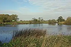 |
Great Wilne
52°52′22″N 1°19′11″W / 52.87291°N 1.31980°W / 52.87291; -1.31980 (Derwent Mouth) |
– |
|
-
|
Confluence with the Trent
|